Have found a very nice tour from Haukeliseter.
From Haukeliseter to Kvanndalen, Holmavatnhytta and back to Haukeliseter
Back
|
Cabins: Kvanndalen Haukeliseter Holmavatnhytta
Haukeliseter to Kvanndalen Tourist Cabin
Kvanndalen is a landscaping area.
Length: 23 km
Tour from Haukeliseter is meant for: 9 hours
Map: Norway Series 109024 Haukeli
Marking: DNT mark
Season: Summer
Area: Haukeliseter
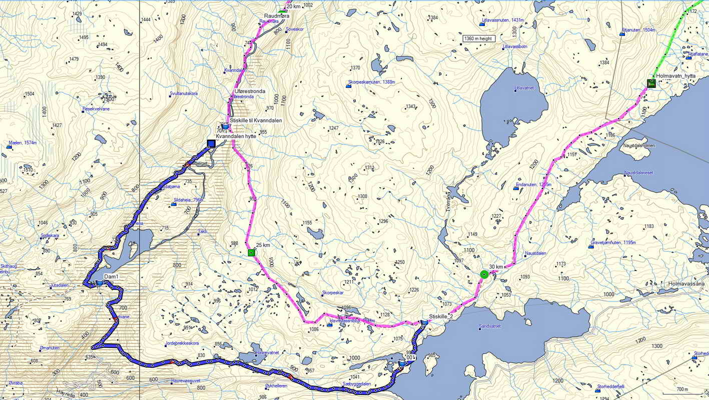
Start from Haukeliseter and go down Kvanndalen to Kvanndalen Tourist Lodge. This is a demanding trip of approx. 9 hours.
One can stay in Kvanndalen Tourist Cabin or stay in a tent.
From Haukeliseter, the route passes along Ståvatnet eastwards, passes the dam and crosses Kjelaelva. Here the roadside for the route to Holmavatn. From here along the south side of the lake in lush, light and fine high mountain terrain.
The exit of Kistetjørn passes over the full year bridge. From Ståvassvika it rises evenly up the Ståvass valley, the last kilometer often on a lot of snow. Great view north to Store and Vesle Nup. From the watershed it carries it down the peculiar and wild Kvanndalen. At Torshidleren (it is dry, and still a good shelter), the valley narrows into a canyon. Isåna forms a nice waterfall where it is pouring into the gorge.
The trip further down the lush valley is an experience. The stems are in line and the river flows between soft grasses. Veidele to the Holmavatn and Bleskestadmoen squares pass just before Kvanndalen Tourist Lodge, located on a large grassy plains at Svultanuten, and is a natural part of an old seats area.
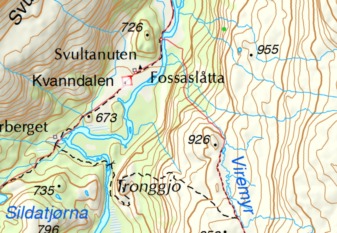
The bridge over the river where the path to Holmavaten goes is removed. About 500m above Kvanndal cabinOne might try to wander a little further up in the river to try to wade over the river.
Kvanndalen Tourist Cabin to Holmavatnhytta
Length: 15 km
If the bridge is broken and one must walk via the dam, the length is 18.8 km,
Tour from Kvandalen Tourist Cabin is intended for: 5 hours
The time via the dam is 6 hours
Map: Norway Series 109024 Haukeli
Marking: DNT mark
Season: Summer
Area: Kvanndalen
In Holmavatnhytta one can stay overnight. The exception is 19 august 8. september when the cabin is closed . ¨
1 : New year-round bridge going to Holmevatn / Sandvatnet / Bleskestadmoen is mounted after a few years without bridge
To get to the new bridge you have to walk 600m from the cabin to the west on to Helleberget take a cross and follow the mark on a new path 550m to Tronggjo. From the new full year bridge, a new trail follows 300 altitude meters on a new path up to the old trail near the top 958moh. The trail is demanding and there are chain chains 2 places. The reward is that you have amazing views, virtually all the new trail at 2km.
If you want to go through the dam, you do not take one off in this crossroads but continue straight ahead.
3. NB! The former bridge over Kvanndalsåna just north of Kvanndalshytta is destroyed and it will not be made a new bridge here . The T-marked path between Kvanndalen and Holmavatn is therefore not possible to go if you do not come across the river here by wading.
So if you want to go from Kvanndalen to Holmavatn, here are three choices :
1. Walk the new path and bridge over Tronggjo and onto the old path towards Holmavatn. About 14.6 km
2. Go from Kvanndalen and follow the trail down the dam and to Sandvatn by the road. About 18.8 km
3. You can wade over the river 500m above the Kvanndalen cabin and follow the old trail towards Holmavatn. About 15 km
2. From Kvanndalen Tourist Lodge you follow the valley south along the T-marked path until you reach Kvanndalsdemningen. Turn left / east of the path you walk on (the new path is neither signposted or T-marked) and cross the dam and onto the road. Follow the construction road for a couple of kilometers down Kvelvane, then straight east up Sæbyggedalen to Sandvatnet. The line along the road is neither signposted nor the T-marked. When the construction road stops at Sandvatnet, turn left onto the T-marked path. Follow the trail north along the west side of Sandvatnet and right into Holmavatnhytta.
Der anleggsveien stanser ved Sandvatnet, tar du til venstre inn på T-merket sti. Følg stien nordover langs vestsiden av Sandvatnet og helt inn til Holmavatnhytta.
Alternative route between Kvanndalen and Holmavatn is therefore the blue trail down via the dam.
Otherwise, follow the red path if one can wade 500m above Kvanndalen.
Touch the text or image to enlarge the map
The new path of Tronggjo
Touch the text or image to enlarge the map
Holmavatn to Haukeliseter
Length: 16 km
Tour from Holmavatn calculated for: 6 hours
Map: Norway Series 109024 Haukeli
Marking: DNT mark
Season: Summer
Area: Haukeliseter
Then go back to Haukeliseter via the Turistskardet.
The trail starts in quite flat terrain past planting rabbits and on wide grassy nuts. Then it goes up towards Turistskardet through the big stone rock when the the snow is gone late in the year.
From the highest point of the route, Turistskaret 1330 moh, there is a nice view back towards Holmavatnet and Fitjanuten.
From the Turistskaret and down the slopes in the Vassdalen valley there is snow fading to far out during the summer. Here is a knot landscape characterized by marked moreneryggs and other traces of ice age
Then it goes down on the eastern side of Vassdalstjørn and down the Vassdalen valley in a magnificent high mountain nature to the railroad to Bjåen and along Fjellvåknuten.
Vassdalselvi passes on a strong full year bridge. The route continues in small hilly terrain, partly through dwarf birch, quay and moist sloping terrain. From there north to Kisteelvi crossed on a small bridge. Then Path divide here for the route to Kvanndalen.
Then cross Kjelaelva and past the dam and along Ståvatn and west to Haukeliseter.
One should have a tent and cooking equipment for safety.
Food must be included as there is no food in the Kvanndalen Tourist Lodge .
If one fails to go all the way to the cabin on the first day, one can look up the tent, as the distance day 2 is not that long.
The whole trip is 3 days. The third day you are back on Haukeliseter.
I think it's incredibly nice terrain here and the whole trip is 53km.
One walks in high terrain so there will be some snow here. One should follow the snow map before one walks.
Mountain messages. Summer mountain waiting for you (Haukeliseter Kvanndalen)
|